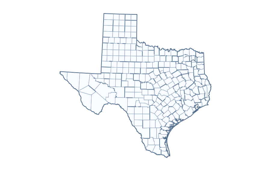
Texas County Map with Cities
Explore geography, source year and identifier definitions before using the map.
Explore this historical reference layer and search its county or county-equivalent names and FIPS identifiers. Alphabetical list as contained in the bundled historic dataset. This is not a verified current count. 254 reference entries Source limitations: Geometry from bundled Basemap Texas Map
County and County-Equivalent Reference List
County / equivalent FIPS (dataset) Anderson 48001 Andrews 48003 Angelina 48005 Aransas 48007 Archer 48009 Armstrong 48011 Atascosa 48013 Austin 48015 Bailey 48017 Bandera 48019 Bastrop 48021 Baylor 48023 Bee 48025 Bell 48027 Bexar 48029 Blanco 48031 Borden 48033 Bosque 48035 Bowie 48037 Brazoria 48039 Brazos 48041 Brewster 48043 Briscoe 48045 Brooks 48047 Brown 48049 Burleson 48051 Burnet 48053 Caldwell 48055 Calhoun 48057 Callahan 48059 Cameron 48061 Camp 48063 Carson 48065 Cass 48067 Castro 48069 Chambers 48071 Cherokee 48073 Childress 48075 Clay 48077 Cochran 48079 Coke 48081 Coleman 48083 Collin 48085 Collingsworth 48087 Colorado 48089 Comal 48091 Comanche 48093 Concho 48095 Cooke 48097 Coryell 48099 Cottle 48101 Crane 48103 Crockett 48105 Crosby 48107 Culberson 48109 Dallam 48111 Dallas 48113 Dawson 48115 DeWitt 48123 Deaf Smith 48117 Delta 48119 Denton 48121 Dickens 48125 Dimmit 48127 Donley 48129 Duval 48131 Eastland 48133 Ector 48135 Edwards 48137 El Paso 48141 Ellis 48139 Erath 48143 Falls 48145 Fannin 48147 Fayette 48149 Fisher 48151 Floyd 48153 Foard 48155 Fort Bend 48157 Franklin 48159 Freestone 48161 Frio 48163 Gaines 48165 Galveston 48167 Garza 48169 Gillespie 48171 Glasscock 48173 Goliad 48175 Gonzales 48177 Gray 48179 Grayson 48181 Gregg 48183 Grimes 48185 Guadalupe 48187 Hale 48189 Hall 48191 Hamilton 48193 Hansford 48195 Hardeman 48197 Hardin 48199 Harris 48201 Harrison 48203 Hartley 48205 Haskell 48207 Hays 48209 Hemphill 48211 Henderson 48213 Hidalgo 48215 Hill 48217 Hockley 48219 Hood 48221 Hopkins 48223 Houston 48225 Howard 48227 Hudspeth 48229 Hunt 48231 Hutchinson 48233 Irion 48235 Jack 48237 Jackson 48239 Jasper 48241 Jeff Davis 48243 Jefferson 48245 Jim Hogg 48247 Jim Wells 48249 Johnson 48251 Jones 48253 Karnes 48255 Kaufman 48257 Kendall 48259 Kenedy 48261 Kent 48263 Kerr 48265 Kimble 48267 King 48269 Kinney 48271 Kleberg 48273 Knox 48275 La Salle 48283 Lamar 48277 Lamb 48279 Lampasas 48281 Lavaca 48285 Lee 48287 Leon 48289 Liberty 48291 Limestone 48293 Lipscomb 48295 Live Oak 48297 Llano 48299 Loving 48301 Lubbock 48303 Lynn 48305 Madison 48313 Marion 48315 Martin 48317 Mason 48319 Matagorda 48321 Maverick 48323 McCulloch 48307 McLennan 48309 McMullen 48311 Medina 48325 Menard 48327 Midland 48329 Milam 48331 Mills 48333 Mitchell 48335 Montague 48337 Montgomery 48339 Moore 48341 Morris 48343 Motley 48345 Nacogdoches 48347 Navarro 48349 Newton 48351 Nolan 48353 Nueces 48355 Ochiltree 48357 Oldham 48359 Orange 48361 Palo Pinto 48363 Panola 48365 Parker 48367 Parmer 48369 Pecos 48371 Polk 48373 Potter 48375 Presidio 48377 Rains 48379 Randall 48381 Reagan 48383 Real 48385 Red River 48387 Reeves 48389 Refugio 48391 Roberts 48393 Robertson 48395 Rockwall 48397 Runnels 48399 Rusk 48401 Sabine 48403 San Augustine 48405 San Jacinto 48407 San Patricio 48409 San Saba 48411 Schleicher 48413 Scurry 48415 Shackelford 48417 Shelby 48419 Sherman 48421 Smith 48423 Somervell 48425 Starr 48427 Stephens 48429 Sterling 48431 Stonewall 48433 Sutton 48435 Swisher 48437 Tarrant 48439 Taylor 48441 Terrell 48443 Terry 48445 Throckmorton 48447 Titus 48449 Tom Green 48451 Travis 48453 Trinity 48455 Tyler 48457 Upshur 48459 Upton 48461 Uvalde 48463 Val Verde 48465 Van Zandt 48467 Victoria 48469 Walker 48471 Waller 48473 Ward 48475 Washington 48477 Webb 48479 Wharton 48481 Wheeler 48483 Wichita 48485 Wilbarger 48487 Willacy 48489 Williamson 48491 Wilson 48493 Winkler 48495 Wise 48497 Wood 48499 Yoakum 48501 Young 48503 Zapata 48505 Zavala 48507 UScounties shapefile (EPSG:4269), source vintage not verified. Do not quote its numeric totals as present-day administrative counts. Downloaded SVG files include no legal accuracy warranty.


How to read a five-digit Texas county GEOID
A typical US Census county GEOID contains a two-digit state FIPS prefix followed by a three-digit county code. Texas uses prefix 48. Thus the sample code 48001 identifies Anderson County in the legacy list. GEOIDs identify jurisdictions, not mailing ZIP codes, and a city can span multiple counties.
The legacy bundled list must not be relabeled as a current population table; no county population estimates or county-seat values have been sourced for this release. Compare it with a chosen current Census Gazetteer/TIGER vintage before publishing boundary claims.
Understanding the county-equivalent system in Texas
Some city and county boundaries overlap, while unincorporated areas lie outside municipal limits. County maps must state the record year and jurisdiction definition. County-equivalent units are the level used in many Census datasets; state-level terminology and changes over time can affect counts and boundaries.
Examples of Texas county GEOIDs
| Legacy reference name | Five-digit GEOID | County part |
|---|---|---|
| Anderson | 48001 |
001 |
| Andrews | 48003 |
003 |
| Angelina | 48005 |
005 |
| Aransas | 48007 |
007 |
| Archer | 48009 |
009 |
| Armstrong | 48011 |
011 |
The first two FIPS digits identify the state in this dataset (48); the following three digits identify a county or county-equivalent record. Preserve leading zeros when storing these IDs in spreadsheets, CSV or databases.
How to read and verify the county map
- Start with the state outline and use the on-page search to find a county or full FIPS code.
- Check whether the entry represents a county, parish, borough, census area or independent city.
- Use the source-year label when referencing boundaries or computing statistics.
- For modern population, area or county-seat statistics, join this table to a verified dated government source rather than guessing from the map.
County lists versus postal addresses
A ZIP code, county name and postal city serve different purposes. A mailing address can use a neighboring city’s name, and one ZIP can intersect several counties. Use a point-in-polygon lookup against a properly dated jurisdiction layer when an exact address-to-county answer matters.
Official data to cross-check
The U.S. Census Bureau publishes 2025 Gazetteer county tables with area and representative coordinate fields, and TIGER/Line boundaries. The Gazetteer files do not include population; a separately dated Census or ACS table is required for that value.
10 questions about Texas
Questions based on search intent and competitor topics; not a verified Google People Also Ask feed.
How many counties or county equivalents are listed for Texas?
The bundled reference currently contains 254 entries for Texas. Because the underlying source vintage is not confirmed against the latest Census release, verify the authoritative current count before quoting it.
What is the county FIPS code for Texas?
Texas has state-level FIPS prefix 48. A complete county GEOID combines the two-digit state code and a three-digit county code. For example, Anderson has the stored GEOID 48001.
How do I locate a county on the Texas map?
Use the county-name/FIPS table and consult an authoritative labeled map to match a name to its boundary. A point near a border needs a precise coordinate-based check.
Can I download a blank Texas county map?
Check the associated printable-map page. County outlines require actual county geometry; an exterior state outline alone does not provide individual county borders.
Does the list include all current county equivalents in Texas?
The page displays records in the bundled historical reference, not a certified current list. Independent cities and similar county equivalents require careful definition.
Is the Texas county data from the latest Census year?
No current-vintage certification is claimed for this local dataset. Compare names and GEOIDs against a dated TIGER/Line or Census Gazetteer file.
What is the difference between a county and a ZIP Code in Texas?
County boundaries are government/statistical administrative areas; ZIP Codes are postal delivery identifiers and often cross counties. ZIP Code Tabulation Areas are Census approximations.
Can I look up a Texas county by address?
An authoritative geocoding service or Census Geocoder can map an address to an official county. County names alone do not determine the county of every address.
Where do I find county population and land area for Texas?
Use a named Census population-estimate vintage for people and a Gazetteer/TIGER data year for area. Avoid mixing Census years when calculating density or ranks.
Can I use Texas county borders for property or legal decisions?
No. The reference is intended for education and general exploration. Property and administrative boundary decisions require current authoritative local records and licensed surveys where appropriate.
Editorial and data status: This is an unpublished reference draft. The information must be checked before the page can be treated as current geographic data or production-ready research.