
Mississippi County Map with Cities
Explore county and ZCTA boundaries
Counties: generalized 2025 TIGERweb. ZIP areas: 2020 Census ZCTAs, not USPS delivery ZIP borders. These datasets are different vintages.
Use the load button to fetch the dated Census geometry.
| Geographic feature | GEOID | Land area (km²) |
|---|
Source: U.S. Census Bureau TIGERweb. The service can be unavailable or rate-limited. Do not treat estimates as legal property boundaries.
Explore geography, source year and identifier definitions before using the map.
Explore this historical reference layer and search its county or county-equivalent names and FIPS identifiers. Alphabetical list as contained in the bundled historic dataset. This is not a verified current count. 82 reference entries Source limitations: Geometry from bundled Basemap Mississippi Map
County and County-Equivalent Reference List
County / equivalent FIPS (dataset) Adams 28001 Alcorn 28003 Amite 28005 Attala 28007 Benton 28009 Bolivar 28011 Calhoun 28013 Carroll 28015 Chickasaw 28017 Choctaw 28019 Claiborne 28021 Clarke 28023 Clay 28025 Coahoma 28027 Copiah 28029 Covington 28031 DeSoto 28033 Forrest 28035 Franklin 28037 George 28039 Greene 28041 Grenada 28043 Hancock 28045 Harrison 28047 Hinds 28049 Holmes 28051 Humphreys 28053 Issaquena 28055 Itawamba 28057 Jackson 28059 Jasper 28061 Jefferson 28063 Jefferson Davis 28065 Jones 28067 Kemper 28069 Lafayette 28071 Lamar 28073 Lauderdale 28075 Lawrence 28077 Leake 28079 Lee 28081 Leflore 28083 Lincoln 28085 Lowndes 28087 Madison 28089 Marion 28091 Marshall 28093 Monroe 28095 Montgomery 28097 Neshoba 28099 Newton 28101 Noxubee 28103 Oktibbeha 28105 Panola 28107 Pearl River 28109 Perry 28111 Pike 28113 Pontotoc 28115 Prentiss 28117 Quitman 28119 Rankin 28121 Scott 28123 Sharkey 28125 Simpson 28127 Smith 28129 Stone 28131 Sunflower 28133 Tallahatchie 28135 Tate 28137 Tippah 28139 Tishomingo 28141 Tunica 28143 Union 28145 Walthall 28147 Warren 28149 Washington 28151 Wayne 28153 Webster 28155 Wilkinson 28157 Winston 28159 Yalobusha 28161 Yazoo 28163 UScounties shapefile (EPSG:4269), source vintage not verified. Do not quote its numeric totals as present-day administrative counts. Downloaded SVG files include no legal accuracy warranty.
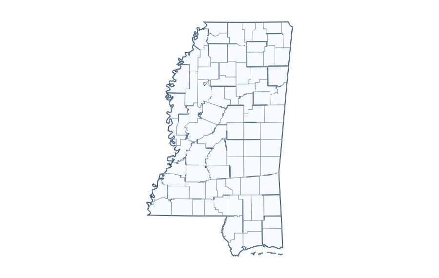

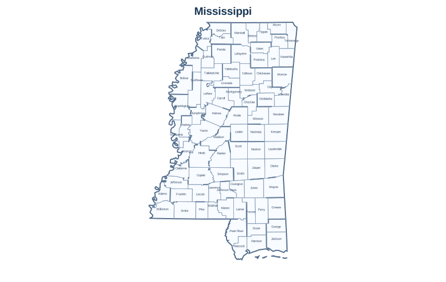
Understanding the county-equivalent system in Mississippi
Some city and county boundaries overlap, while unincorporated areas lie outside municipal limits. County maps must state the record year and jurisdiction definition. County-equivalent units are the level used in many Census datasets; state-level terminology and changes over time can affect counts and boundaries.
Examples of Mississippi county GEOIDs
| Legacy reference name | Five-digit GEOID | County part |
|---|---|---|
| Adams | 28001 |
001 |
| Alcorn | 28003 |
003 |
| Amite | 28005 |
005 |
| Attala | 28007 |
007 |
| Benton | 28009 |
009 |
| Bolivar | 28011 |
011 |
The first two FIPS digits identify the state in this dataset (28); the following three digits identify a county or county-equivalent record. Preserve leading zeros when storing these IDs in spreadsheets, CSV or databases.
How to read and verify the county map
- Start with the state outline and use the on-page search to find a county or full FIPS code.
- Check whether the entry represents a county, parish, borough, census area or independent city.
- Use the source-year label when referencing boundaries or computing statistics.
- For modern population, area or county-seat statistics, join this table to a verified dated government source rather than guessing from the map.
County lists versus postal addresses
A ZIP code, county name and postal city serve different purposes. A mailing address can use a neighboring city’s name, and one ZIP can intersect several counties. Use a point-in-polygon lookup against a properly dated jurisdiction layer when an exact address-to-county answer matters.
Official data to cross-check
The U.S. Census Bureau publishes 2025 Gazetteer county tables with area and representative coordinate fields, and TIGER/Line boundaries. The Gazetteer files do not include population; a separately dated Census or ACS table is required for that value.
How to use the Mississippi county GEOID list
Our bundled Mississippi reference includes 82 county or county-equivalent names. These are identifiers from a historical/unverified-vintage dataset, not a verified current list of official county populations or boundaries. Use the first two digits to recognize the state FIPS prefix 28.
| County | Five-digit GEOID | County suffix |
|---|---|---|
| Adams | 28001 | 001 |
| Alcorn | 28003 | 003 |
| Amite | 28005 | 005 |
| Attala | 28007 | 007 |
| Benton | 28009 | 009 |
| Bolivar | 28011 | 011 |
| Calhoun | 28013 | 013 |
| Carroll | 28015 | 015 |
| Chickasaw | 28017 | 017 |
| Choctaw | 28019 | 019 |
| Claiborne | 28021 | 021 |
| Clarke | 28023 | 023 |
| Clay | 28025 | 025 |
| Coahoma | 28027 | 027 |
| Copiah | 28029 | 029 |
| Covington | 28031 | 031 |
| DeSoto | 28033 | 033 |
| Forrest | 28035 | 035 |
| Franklin | 28037 | 037 |
| George | 28039 | 039 |
| Greene | 28041 | 041 |
| Grenada | 28043 | 043 |
For publication-grade administrative statistics, join county GEOIDs to a specified release of the US Census geography/ACS tables. County-seat, income and population columns must be separately sourced and labeled by year. A postal ZIP can cross a county line, so county matching from a ZIP alone is not always exact.
Official cross-checks: Census TIGER/Line geographic files · Census ACS data.
10 questions about Mississippi
Questions based on search intent and competitor topics; not a verified Google People Also Ask feed.
How many counties or county equivalents are listed for Mississippi?
The bundled reference currently contains 82 entries for Mississippi. Because the underlying source vintage is not confirmed against the latest Census release, verify the authoritative current count before quoting it.
What is the county FIPS code for Mississippi?
Mississippi has state-level FIPS prefix 28. A complete county GEOID combines the two-digit state code and a three-digit county code. For example, Adams has the stored GEOID 28001.
How do I locate a county on the Mississippi map?
Use the county-name/FIPS table and consult an authoritative labeled map to match a name to its boundary. A point near a border needs a precise coordinate-based check.
Can I download a blank Mississippi county map?
Check the associated printable-map page. County outlines require actual county geometry; an exterior state outline alone does not provide individual county borders.
Does the list include all current county equivalents in Mississippi?
The page displays records in the bundled historical reference, not a certified current list. Independent cities and similar county equivalents require careful definition.
Is the Mississippi county data from the latest Census year?
No current-vintage certification is claimed for this local dataset. Compare names and GEOIDs against a dated TIGER/Line or Census Gazetteer file.
What is the difference between a county and a ZIP Code in Mississippi?
County boundaries are government/statistical administrative areas; ZIP Codes are postal delivery identifiers and often cross counties. ZIP Code Tabulation Areas are Census approximations.
Can I look up a Mississippi county by address?
An authoritative geocoding service or Census Geocoder can map an address to an official county. County names alone do not determine the county of every address.
Where do I find county population and land area for Mississippi?
Use a named Census population-estimate vintage for people and a Gazetteer/TIGER data year for area. Avoid mixing Census years when calculating density or ranks.
Can I use Mississippi county borders for property or legal decisions?
No. The reference is intended for education and general exploration. Property and administrative boundary decisions require current authoritative local records and licensed surveys where appropriate.
Editorial and data status: This is an unpublished reference draft. The information must be checked before the page can be treated as current geographic data or production-ready research.